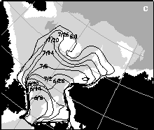
 Contours of the summer ice retreat in the Chukchi Sea
 The picture above shows the retreat of the ice edge in the summer of 1994 in the Chukchi Sea. The contour lines of the approximate ice edge at six-day intervals are derived from the 19GHz channel of the DMSP SSM/I instrument, which measures passive microwave radiation from the sea surface. Because natural microwave radiation emitted from the earth is affected differently by the presence of sea water and ice, it can be used to determine the extent of the polar ice cover, as well as other surface properties. In the picture, the ice edge contours are shown superimposed on a four-color bathymetry map showing the underwater topography of the Chukchi Sea. The white areas are shallows (0-40m), the dark grey is deep water (>60m) and land is black.
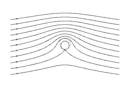
The picture demonstrates that as the ice retreats it leaves a tongue of unmelted ice for about two weeks over Herald Shoal, an abrupt seamount which can be seen as a roughly circular white region in about the center of the picture. The explanation for this feature may be attributable to a phenomenon known as a Taylor column, which causes cold water to be trapped above the sea mount as it is washed by currents coming into the arctic sea through the Bering Strait (lower left in the picture.) The feature recurs each summer during the melt season over both Herald Shoal and Hanna Shoal, a smaller shoal off the Alaska coast near Barrow Canyon. Click on the picture to see a larger figure showing the ice edge retreat for three different years.
For more about this research, please refer to our paper :